|

180 TYWI TIDAL FLOOD PLAIN 
GRID REFERENCE: SN 399147
AREA IN HECTARES: 364.80
Historic Background
The tidal floodplain on both sides of the River Tywi is a landscape
of many periods, though most of it - in its present form - is of relatively
recent origin. However, the present course of the river in the northern
half of the area appears to have remained fairly constant since at least
the Medieval period, when the west bank lay within the Lordships of Carmarthen
and Llansteffan and the east bank belonged to the Lordship of Kidwelly
(Rees 1932). Several areas of saltmarsh are mentioned in contemporary
accounts, when it was held directly from the crown as common, seasonal
grazing land, as the place-names 'Morfa Brenin' and 'King and Queen's
Marsh' demonstrate (James 1980, 42-44). An area of common land also lay
to the south of the area at Morfa Uchaf, near Ferryside.
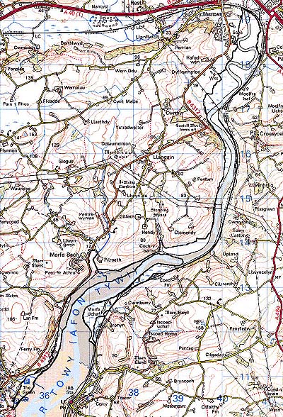
Base map reproduced from the OS map with the permission
of Ordnance Survey on behalf of The Controller of Her Majesty's Stationery
Office, © Crown Copyright 2001.
All rights reserved. Unauthorised reproduction infringes Crown Copyright
and may lead to prosecution or civil proceedings. Licence Number: GD272221
Description and essential historic landscape components
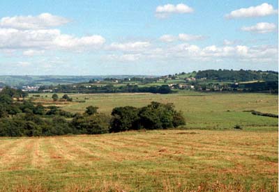
The tidal floodplain of the River Tywi stretches from Llansteffan in the
south to Carmarthen in the north, a distance of approximately 10 km. Land
in this area consists in the main of recently accumulated silts and sands.
This is markedly so in the southern part of the area where there is just
Llansteffan beach and salt marsh. Further upstream deposits are older,
and comprise saltmarsh; nevertheless, they are subjected to frequent tidal
inundation. The history of drainage and reclamation here has not been
researched; however, south of Carmarthen where the valley opens out into
a flood plain approaching 1 km wide, drainage ditches and wire fences
divide the area into rough, seasonal pasture. Except for an area around
Pil-roath and Coed Marsh, there does not seem to have been any attempt
at concerted drainage of the area by the construction of sea defences,
and the lack of enclosure or any immediately detectable physical evidence
of formal drainage systems eg. either grip, or ridge and vurrow, in the
southern half of the area, suggests that it has always remained undrained
marsh and sand.
Recorded archaeology is confined to such maritime, intertidal features as fish-traps, wreck sites and navigation markers of Post-Medieval date. However, a Bronze Age findspot has been recorded near Llansteffan.
Buildings are limited to a Post-Medieval lime-kiln.
This is a well-defined landscape area lying between High Water Mark and the enclosed, rising ground to the east and west. Only to the north, where the area merges with the tidal marsh below Carmarthen town is the boundary indistinct.