Home > Historic Landscape Characterisation > Carmarthen Bay Estuary Area > |

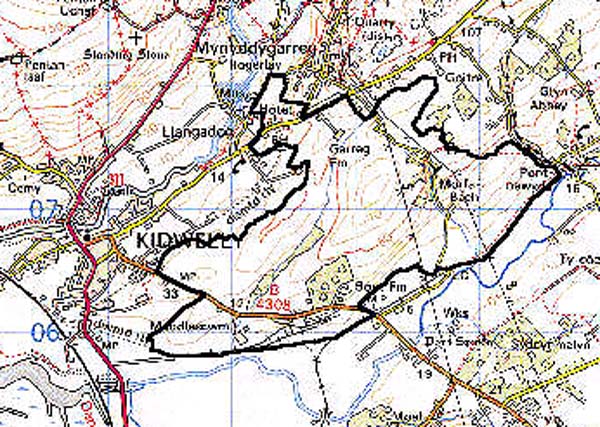
 MORFA BACH
GRID REFERENCE: SN 430069
AREA IN HECTARES: 366.70
Historic Background
A foreignry of the Lordship of Kidwelly (Rees 1953, 205-212), with a very good recorded, post-Conquest landscape history. The southern half of the area was, from the 14th century at least, occupied by the holding of Muddlescwm, while the Medieval Glyn Forest extended into the north of the area around Morfa Bach (Rees 1932). Muddlescwm was first mentioned in 1342 when it was granted to Thomas Peerys (Jones 1985, 15). The exact status of the holding, and the nature of its tenure are unknown. In 1394 John Vachan granted a lease on the 'manor' of Muddlescwm 'except a wood at Modelyscom and a tenement in Le Langstret', and it may be associated with a former settlement, but it was always answerable to the foreignry court at Kidwelly (ibid.). In 1408 it comprised '2 messuages, 4 carucates, 12 acres of meadow, 100 acres of wood, and 8 acres of marsh and pasture' (ibid.); it may be that enclosure of the manorial lands had already begun. By the mid 15th century the Dwnns of Penallt, who became one of Wales' leading gentry families and commentators, had acquired the holding. This area was subject to a fairly detailed survey in 1609 in which Cwm Hêd, as 'Combeheade', was described as a 'moor... containing two acres or thereabouts'. Between it and Muddlescwm was a common belonging to the freeholders of the foreignry, while Morfa Bach was also common grazing and contained 4 acres 'or thereabouts' (Rees, 1953, 209). Muddlescwm later passed to the Morgans, then the Mansels, and is now a freehold farm. This area was only marginally affected by the coal industry which left its mark on most of the surrounding landscape areas, but a coal washery established at Muddlescwm, now demolished, was still operational until c.1990. Kymer's Canal of 1766-6, taken over by a railway in 1865, forms the southern limit of the area,
Base map reproduced from the OS map with the permission
of Ordnance Survey on behalf of The Controller of Her Majesty's Stationery
Office, © Crown Copyright 2001.
All rights reserved. Unauthorised reproduction infringes Crown Copyright
and may lead to prosecution or civil proceedings. Licence Number: GD272221
 Description and essential historic landscape components
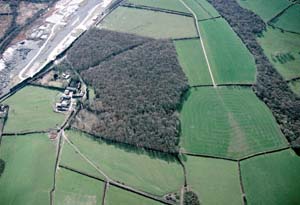
An area of large, rectilinear enclosures lying between 5 m and 90 m which, at least in part, probably date to the late Medieval period. The well-defined blocks of deciduous woodland at Coed Mawr, Cwm Hêd and Morfa Bach may also be Medieval, and represent ancient woodland. Present land-use is now all improved pasture with a small amount of arable. The fields are divided by earth banks with hedges which are generally well-maintained, though a small number are becoming overgrown; wire fences are widespread. Settlement comprises scattered farms and dwellings which are mostly 19th century or modern.
Archaeology recorded within the area belongs mainly to the Medieval and Post-Medieval periods, but does include a Bronze Age standing stone. The remains of a Medieval chapelry, associated with a well, Capel Mihangel, lie just west of Muddlescwm (Jones 1985, 12). A second chapelry and well, Capel Teilo, which was mentioned in 1593 (Jones 1991, 255-259) lies towards the north of the area.
Post-Medieval sites and structures are mainly associated with the coal industry and include Kymer's Canal, Muddlescwm quay and bridges, the later railway lines and sidings, the former coal washery and a public house.
The present mansion house at Muddlescwm is 17th century but has earlier origins, and may be associated with a Medieval settlement; it was unlisted in 1999. Other farms are mostly 19th century with stone-built, two-storey, three-bay farmhouses in the vernacular tradition, though some 20th century houses are present. Many farms have relatively large ranges of 19th century farm outbuildings, some arranged semi-formally around a yard, as well as modern agricultural buildings.
A distinctive historic landscape area of large, possibly Medieval enclosures distinct from reclaimed marsh to the south and east and smaller, former strip fields to the north and west.