Home > Historic Landscape Characterisation > Carmarthen Bay Estuary Area > |

 LLANDYRY AND PINGED STRIP FIELDS
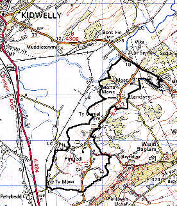
GRID REFERENCE: SN 426043
AREA IN HECTARES: 223.30
Historic Background
A strip of land southeast of Pinged Marsh which, like like neighbouring areas formed part of Pembrey Manor during the Medieval period and, with Maenor Penrhyn to the north-east, was initially held of the Lordship of Kidwelly as both a Welshry and a foreignry (Rees 1953, 200). It enjoyed manorial status from at least 1361 under the Butlers, who possibly held it as a demesne manor, and by 1630 under the Vaughans it had become independent of Kidwelly lordship (Jones 1983, 18). However, 'one tenement in the said foreignry (of Kidwelly) at a place called Pinget (sic), late in the tenure of John Ungoed, containing six acres of lands or thereabouts' had been claimed as part of the Kidwelly demesne in 1609 (Rees 1953, 206). Ridge and furrow cultivation appears to have been carried out within at least part of the area, and it is apparent from the Pembrey tithe map of 1841 that the boundaries within the area, and around Pinged in particular, represent the enclosure of former field strips. This has given rise to rectilinear enclosures which are like those within Area 166, but in 1841 the process appears to have been less well advanced in Area 165, and may therefore have been a relatively recent phenomenon. The present farms Ty Mawr, Ty-canol, Ty Cornel and Moat all appear to be no earlier than the late 18th-century. The area lies within the parish of Pembrey and to the north is Llandyry, a chapel-of-ease, which in 1353 was, with Pembrey Church, granted to the New College of Leicester (Ludlow 1998). There is no firm evidence for the pre-conquest religious use of the site. It was granted burial rights in 1876. This area enters the coalfield at its far north-eastern end and it is here that the greatest landscape change occurred with the establishment of a number of coal-pits and iron-workings, some of them as early as the 17th century (Thomas, 1937, 2) and, in 1814-24, a spur of the Kidwelly & Llanelly canal which led to the Trimsaran collieries (see Area 156). It was replaced by a railway line in 1865 (Ludlow 1999, 28). Piecemeal 20th century housing development has occurred, and a later 20th-century poultry farm now occupies part of the area.
Base map reproduced from the OS map with the permission
of Ordnance Survey on behalf of The Controller of Her Majesty's Stationery
Office, © Crown Copyright 2001.
All rights reserved. Unauthorised reproduction infringes Crown Copyright
and may lead to prosecution or civil proceedings. Licence Number: GD272221
 Description and essential historic landscape components
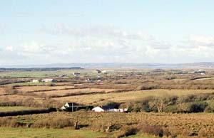
The area is a narrowish southwest-northeast running strip with a general downhill trend to the north-west, from 20 m to just above sea level. It comprises irregular, medium-sized rectilinear enclosures which, particularly around Pinged and Llandyry, represent former strip fields. Boundaries mainly belong to the 18th- and early 19th-century and are earth banks with hedges, some of which are overgrown and have distinctive trees, enclosing both improved and unimproved pasture. Field evidence for ridge and furrow cultivation has been noted at two localities within the northern part of the area. There is little woodland. Settlement is characterised by dispersed farms though there are loose nucleations at the historic sites of Llandyry and Pinged. There is physical evidence for a number of early iron- and coal-pits in the area, some as early as the 17th century. The Kidwelly & Llanelly Canal/railway embankment survives along with the aqueduct built at Moat in 1814-24.
Recorded archaeology is mainly characterised by the industrial features noted above, and structures. However, an Iron Age defended enclosure has also been recognised.
Llandyry Church is a Medieval cruciform church restored in 1876 (Ludlow 1998), but the remainder of the buildings within the area appear to be no earlier than the 18th century and most date to the second half of the 19th century and 20th century. Dwellings comprise small farmhouses, other small houses and cottages. 19th century dwellings are stone-built, two-storey and three-bay in the vernacular tradition. 20th century dwellings are in a variety of styles and materials. There are several 19th century cottages, houses and cottage sites, and a school at Pinged, as well as late 20th century dwellings. 19th century farm outbuildings are stone-built and relatively small, usually consisting of just one range. However Moat is a substantial farmstead comprising good quality buildings from the 18th- and early 19th-century. The canal overbridge at Moat is Grade II listed.
This is a fairly distinct historic landscape area which contrasts sharply with the reclaimed marsh to the north and west. The boundary with the area to the south and east is less well-defined, but the outlines of the former field strips are better-preserved here in than in the neighbouring area.