Home > Historic Landscape Characterisation > Carmarthen Bay Estuary Area > |

 MYNYDD PENBRE WOOD
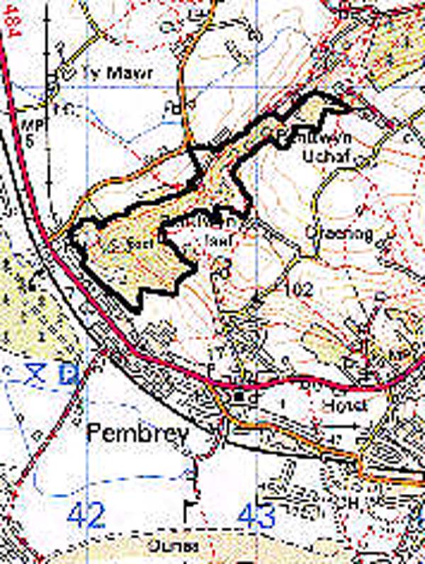
GRID REFERENCE: SN 427023
AREA IN HECTARES: 49.60
Historic Background
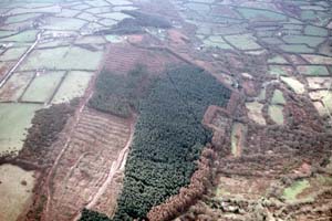
An area of wooded scarp occupying the north-western slope of Mynydd Penbre which, in the historic period, represented a sea-cliff line (James 1991, 147). Mynydd Penbre represented the greater part of Maenor Penrhyn during the Medieval period, which, with the manor of Pembrey, was initially held of the Lordship of Kidwelly as both a Welshry and a foreignry (Rees 1953, 200). It enjoyed manorial status at least as early as 1361 and had, by 1630, become independent of Kidwelly Lordship (Jones 1983, 18). The area was probably wooded throughout the Medieval period (Williams 1981, 5). The southern end, called 'Court Wood', lay within the curtilage of Pembrey Court, the caput of the manor, and the area also contains Coed y Marchog ('Knight's Wood') which was given the same name in 18th century documents (Williams, 1981, 5). The remainder of the area is split between Coed and Coed Rhyal; Coed is a farmstead that is shown in 1891(Ordnance Survey 6" First Edition, Sheet LIII SW). At least four coal levels were operational within Coed Rhyal in the earlier 19th-century, but had closed by 1891 (OS first edition, Sheet LIII SW), while quarries lay near Coed and in Court Wood. In addition, at the foot of the south-west end of Mynydd Penbre lay Craig-lon Colliery which was established in the 18th century, extended in the 19th century, amalgamated with other local collieries as 'Pembrey Collieries Ltd' in 1918, and closed in the 1930s (Ludlow 1999, 31). The southwest end of the area was used as a firing range in the Second World War. A conifer plantation has now been planted across part of the area.
Base map reproduced from the OS map with the permission
of Ordnance Survey on behalf of The Controller of Her Majesty's Stationery
Office, © Crown Copyright 2001.
All rights reserved. Unauthorised reproduction infringes Crown Copyright
and may lead to prosecution or civil proceedings. Licence Number: GD272221
 Description and essential historic landscape components
The area occupies a steep, north-west facing scarp slope dropping from 100 m to just above sea level in an area averaging 150 m in width; it is wider at its southern end where the hillslope turns towards the east, and this latter area contains two Iron Age hillforts (Williams, 1981). It is thickly wooded, predominantly with oak scrub which is largely secondary. The area is predominantly unenclosed but there are remains of ridge and furrow, and plough lynchets with prehistoric origins, to the south (Williams 1981, 11-12), while the far north end is divided by a series of boundaries into irregular rectilinear enclosures, and the central area, around Coed Farm, the only settlement, features a large enclosure. An extensive 20th century conifer plantation occupies a large portion of this area. The Court Wood quarry can still be seen but there is now little physical evidence for the former coal mines. Some artificial hollows and platforms to the south-east relate to use as a firing range in the Second World War (Williams, 1981, 12).
Recorded archaeology is rich and diverse, including the two Iron Age hillforts, two possible Bronze Age round barrows, agricultural features including an ?Iron Age field system, Medieval ridge and furrow, and Post-Medieval industrial features ie. quarries and coal pits.
There are no distinctive buildings.
This historic landscape area contrasts sharply with more level ground at the foot of the hillslope to the north and west and the summit of Mynydd Penbre to the south and east.