Home > Historic Landscape Characterisation > Carmarthen Bay Estuary Area > |

 PEMBREY FOREST
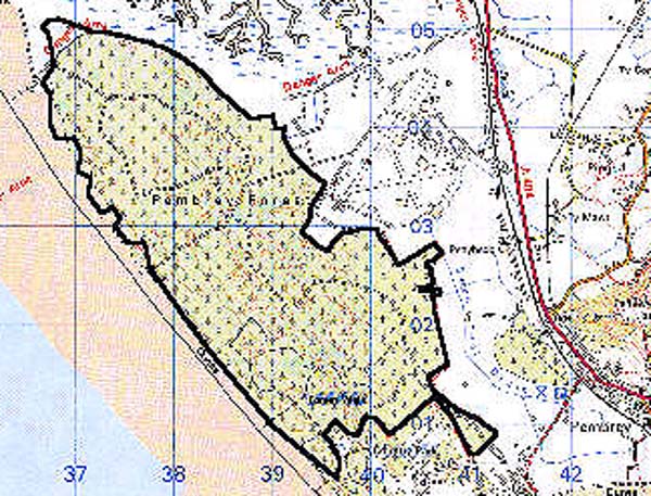
GRID REFERENCE: SN 385027
AREA IN HECTARES: 863.90
Historic Background
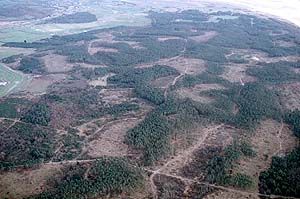
Pembrey Forest occupies the greater part of Pembrey (or 'Towyn') Burrows, an area of sand hills of comparatively recent origin. The Burrows developed at the mouth of the River Gwendraeth Fawr over a long period. Alongside this a series of reclamations occurred around an initial nucleus formed by a tongue of dry land at the foot of Mynydd Penbre, partly represented by the Medieval Manor of Caldicot. The Burrows themselves have developed since the 17th century at least but, according to James, are no earlier than the Medieval period - the earliest date to which shell-midden sites observed within the area can be attributed (James 1991, 159). Sea-walls constructed during the 18th- and early 19th-century extended dry land further north and west of the airfield area, into the area of the Burrows, and dune slacks appear to have developed to the southeast of an original tongue of dry land. The Manor of Caldicot had been merged with the Manor of Pembrey (under the Ashburnhams) by the early 19th-century, when the coastline had extended almost to its present line and most of this area appears already to have been occupied by sand hills, called 'Great Outlet' on the Pembrey tithe map of 1841 and represented as common land. However, the tithe map also shows enclosures to the extreme west and southwest of the area around a farm, Towyn Canol, also shown in 1891 (Ordnance Survey 6" first edition, Sheet LVII NW). During the Second World War, gun emplacements relating to Pembrey Airfield, and the Command Stop Line running from the Bristol Channel to Cardigan Bay, were constructed east-west across the burrows. The entire character area has been planted with coniferous forest since the 1940s.
Base map reproduced from the OS map with the permission
of Ordnance Survey on behalf of The Controller of Her Majesty's Stationery
Office, © Crown Copyright 2001.
All rights reserved. Unauthorised reproduction infringes Crown Copyright
and may lead to prosecution or civil proceedings. Licence Number: GD272221
 Description and essential historic landscape components
There are few historic landscape components in what is in essence a band of sand dunes some 5 km wide and 2 km long over which a conifer plantation has been established. The dunes are substantial, and achieve heights of over 20 m. Only a very small portion of land now under forestry was enclosed farm land, not sand dune; this has not been examined to see if former field boundaries and structures survive, but the outlines of yards, buildings etc. associated with Towyn Canol are shown on the modern Ordnance Survey 1:2500. Prior to the conifer planting, a munitions factory was established at the southern end of this area. The storage bunkers and infrastructure of this factory constitute some of the most important components in the historic landscape, as do the scattered Second World War defensive structures within the forest.
Recorded archaeology is limited to the shell midden, drainage features, and the site of Towyn Canol Farm.
Distinctive buildings are limited to two Second World War gun emplacements and a bunker.
Pembrey Forest is a distinctive and well defined historic landscape area on all sides except to the south. To the south both the forestry and installations associated with the munitions factory spill into the neighbouring area. To the west lies unafforested sand dunes, to the north salt marsh and to the east reclaimed marsh.