Home > Historic Landscape Characterisation > Carmarthen Bay Estuary Area > |

 BROOKLANDS
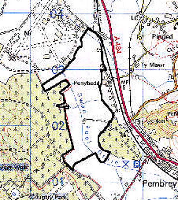
GRID REFERENCE: SN 408024
AREA IN HECTARES: 144.90
Historic Background
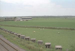
A very distinct area of former salt marsh behind, and to the east of Pembrey Burrows, which developed when the coastline around the burrows lay considerably further east and south than it does at present. At least part of the area was referred to as 'King's Marsh alias Pembrey Marsh' in a survey of 1638 (James 1991, 152), when it appears to have represented open salt marsh set aside for use by the burgesses of Kidwelly, of which sixty acres had recently been enclosed by Sir Richard Vaughan. These enclosures are probably the fields shown on the estate map of Caldicot Manor of 1681 as the 'King's Warth' ('Morfa Brenin' on the Pembrey tithe map, 1841). The four large enclosures, variously subdivided, in the northern half of the area are shown with boundaries identical to those of today, but with variations in subdivision. One of these boundaries, however, represents the line of the sea wall constructed as 'The Bulwarke', probably in 1629 (James, 1991, 152). The area is crossed from north to south by the man-made Swan Pool Drain, which had probably been established by 1762 to empty a pond formerly lying in Area 163, to the south east, into a former creek beyond The Bulwarke, in Area 157. Much of the remainder of Caldicot Manor now lies beneath Pembrey Airfield (Landscape Area 157). The farmstead of Brooklands itself is a later creation and is not shown on the Pembrey tithe map of 1841. During the Second World War a Command Stop Line was constructed between Cardigan Bay and the Bristol Channel, part of the defences of which follow Swan Pool Drain (Page 1996, 20).
Base map reproduced from the OS map with the permission
of Ordnance Survey on behalf of The Controller of Her Majesty's Stationery
Office, © Crown Copyright 2001.
All rights reserved. Unauthorised reproduction infringes Crown Copyright
and may lead to prosecution or civil proceedings. Licence Number: GD272221
 Description and essential historic landscape components
This area consists of flat, reclaimed marsh at, or close to sea level. It is now mostly improved pasture which has been divided into medium-sized irregular enclosures by ditches, dating to the 17th century. In some instances scrubby hedges line the ditches; these are supplemented by wire fences. Alongside tracks hedges are in better condition and are mostly stock-proof. There is no woodland.
Recorded archaeology is limited to drainage features.
There are no distinctive buildings. The later 19th century Brooklands Farm has recently been rebuilt in brick, has a large assemblage of modern farm buildings and is the only settlement in this area. Two Second World War pill-boxes lie within the area.
The borders of the Brooklands historic landscape character area are only well defined to the west against forestry. To the northwest lies the modern landscape of Pembrey Airfield, and to the northeast the later enclosed land of Pinged Marsh. To the south lies more forestry and more intensively enclosed and settled reclaimed marsh.