Home > Historic Landscape Characterisation > Carmarthen Bay Estuary Area > |

 LAQUES
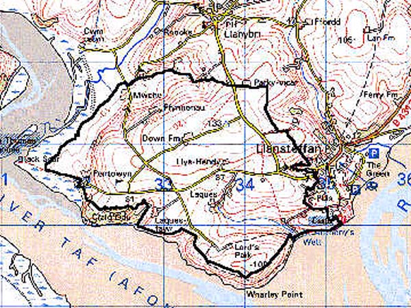
GRID REFERENCE: SN 332106
AREA IN HECTARES: 510.30
Historic Background
An area of undulating country featuring fairly large fields with irregular boundaries and dispersed farmsteads, all the result of the amalgamation and enclosure of fields under emerging gentry families such as the Lloyds of Laques (and The Plas, Llansteffan) in the 17th- and 18th-century. This landscape can be contrasted with those in which the curving shape of former open field strips was fossilised by the Post-Medieval boundaries eg. to the north.To the south-east, in fact, part of the area may have lain within the medieval 'Broadlands Park' (Rees 1932), and have remained unenclosed until the Post-Medieval period. Elements of the Medieval landscape also include Pentowyn Farm, to the west of the area, which was a 120 acre grange granted to St John's Priory, Carmarthen, between 1115 and 1130 by the lord of the Manor of Llangain Alfred Drue (Jones 1991, 4). It contains the site of a chapel apparently dedicated to St Teilo, possibly with pre-Conquest origins (James, n.d.). At the dissolution Pentowyn fell to the Lloyd family of Llansteffan and is now owned by the National Trust. The central farmstead of Laques, with a name derived from the Old English 'lac' (stream), is known to have been occupied since the 14th century when it was the seat of the Reed family; it was acquired by the Lloyds of Llansteffan in 1616 (Jones 1987, 97). Lord's Park farm to the south is, by contrast, an example of a possible medieval settlement reorganised by the Lloyds according to a system of home and tenant farms, typical of 18th century estate re-organisation (James n.d.) and exhibits a farm-house and outbuildings, of good quality, from the late 18th- or early 19th-century. To the east of the area, on the Tywi foreshore, is a spring traditionally dedicated to St Anthony and regarded as an ancient holy well. An adjacent early 19th-century villa was built to take advantage of the sea views by a Captain Scott, typifying the appreciation of natural beauty that had been acquired by the emerging leisured classes (James n.d.).
Base map reproduced from the OS map with the permission
of Ordnance Survey on behalf of The Controller of Her Majesty's Stationery
Office, © Crown Copyright 2001.
All rights reserved. Unauthorised reproduction infringes Crown Copyright
and may lead to prosecution or civil proceedings. Licence Number: GD272221
 Description and essential historic landscape components
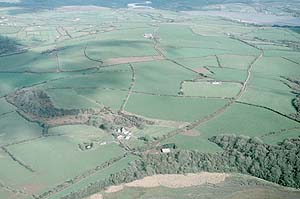
This small historic landscape area lies between the confluence of the Rivers Tywi and Taf and is, in its present form, early Post-Medieval. It rises from sea level into a landscape of rolling hills that achieve a maximum height of over 130m. Most of the land is farmed, the majority of which is improved pasture. There are small stands of ?ancient deciduous woodland on steep slopes, but apart from these this is a very open landscape. Fields tend towards being medium-sized and regular, particularly at higher levels, with boundaries consisting of earth banks topped with hedges. Hedges are well maintained; few are overgrown, and distinctive hedgerow trees are rare. The settlement pattern is of dispersed farms.
Recorded archaeology, in addition to the Medieval and Post-Medieval landscape features noted above, includes Neolithic finds at Pentowyn, two possible Bronze Age standing stones, two possible Iron Age hillforts.
There are some distinctive buildings but none are listed. Farms consist of substantial stone-built dwellings with slate roofs, in the Georgian tradition, usually with a range of stone-built out-buildings as well as modern structures; with the exception of Laques which retains Jacobean features but was extended after 1747 (Jones 1987, 97). There are also Post-Medieval cottages and a school.
To the south this area is extremely well defined by sea cliffs/coastal slope. Similar good boundary definition exists to the west against reclaimed salt marsh, and to the east against Llansteffan village. To the north the exact boundary between this historic landscape character area and the neighbouring area. enclosed strip fields, is less defined but nevertheless these two character areas are distinct.