Home > Historic Landscape Characterisation > Carmarthen Bay Estuary Area > |

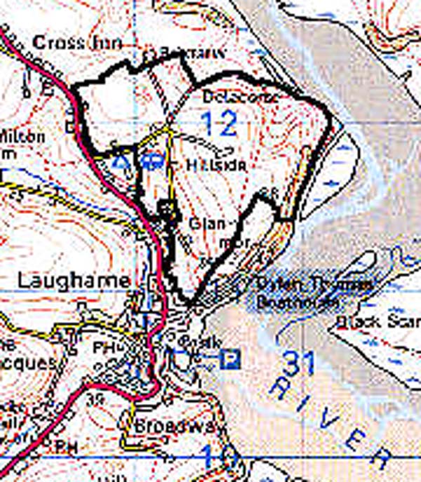
 DELACORSE
GRID REFERENCE: SN 303116
AREA IN HECTARES: 115.20
Historic Background
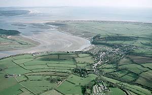
An area immediately east and north of the town of Laugharne, which lay within the Medieval Lordship of Laugharne and was held under manorial tenure. It was probably included within a grant of land made to the burgesses of Laugharne by Sir Guy de Brian in 1278-82 (Williams, n.d.), and was farmed by the burgesses of Laugharne under an open field system. This system seems to have been used throughout the Medieval period but was coming to an end by the early modern period, as documents of late 16th- and 17th-century date contain many references to the creation of closes within the East Field of Laugharne. It is unclear why the East Field should have been subjected to piecemeal enclosure whilst The Hugden remained an open field system, and other presumed open fields were engrossed and carved up into large regular enclosures. Whatever the reason, piecemeal enclosure has created a distinctive pattern of long curving fields that mirror the pattern of strips within the Medieval open field system. It is likely that the two farms in this area, Delacorse and Maesyderi, were created as the open field system was transformed into that of the present day. Cottages, possibly squatter settlements, were established in the 18th- or 19th-century on the steep slopes over looking the Taf estuary. These are now abandoned and the slopes are heavily wooded.
Base map reproduced from the OS map with the permission
of Ordnance Survey on behalf of The Controller of Her Majesty's Stationery
Office, © Crown Copyright 2001.
All rights reserved. Unauthorised reproduction infringes Crown Copyright
and may lead to prosecution or civil proceedings. Licence Number: GD272221
 Description
and essential historic landscape components
Description
and essential historic landscape components
A small area consisting of enclosed strip- or open-fields lying on gently sloping hillsides of pasture, ranging in height from 25m to almost 100m. The fields reflect the former strips and consist of long curving enclosures, though some have coalesced since the 19th century into more regular, rectangular fields. Boundaries consist of banks topped with hedges. Some distinctive hedgerow trees are present, but apart from secondary woodland on steep coastal slopes, which masks cottages abandoned last century, there is no substantial afforested ground in this area. Farmhouses are stone-built, and slate-roofed with outbuildings; Maesyderi has modern outbuildings.
Recorded archaeology is represented by a standing stone and a possible Early Christian inscribed stone.
There are few distinctive buildings but Mapsland has a late Georgian, Grade II listed double-pile farmhouse.
The field pattern in this area distinguishes it from the surrounding enclosed land.