Home > Historic Landscape Characterisation > Carmarthen Bay Estuary Area > |

 TAF VALLEY RECLAIMED MARSH
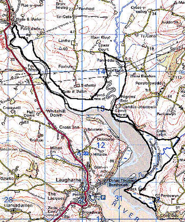
GRID REFERENCE: SN 310127
AREA IN HECTARES: 245.40
Historic Background
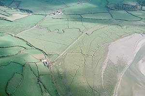
This is a fairly extensive landscape area consisting of several discrete patches of former salt marsh on either side of the Taf Estuary, but mainly to the east. It is clear that the marshland had formed by the Medieval period when it lay within the Lordships of Laugharne to the east, Osterlow in the centre and St Clears to the west, lands that were mainly held under manorial tenure. The eastern part of the area, Mwche Marsh, was known as 'Mundegy Marsh' in the Medieval period when its economic value lay mainly in the ferry to Laugharne which was operational until the 1950s (James, n.d.). In about 1214, Rhys ap Gryffydd granted the western part of this area to the Cistercian Abbey at Whitland, as part of Osterlow Grange (Williams, 1990), but it was probably always marginal land, while the northern end of the area appears to have been common land of St Clears borough. On the dissolution of the abbey in 1539, Sir John Perrot acquired the Whitland estates, including Osterlow (Benson 1996). His son, Thomas, married Dorothy sister of the Earl of Essex, and their daughter, Penelope, married Sir William Lowther, a well known astronomer, who died at Trefenty in 1615 (ibid.). It is probable that the Trefenty estate encompassed the lands of the former grange. The estate later passed into the Drummond family, whose land leases of the late 17th-century document the construction of sea defences and enclosure of salt marsh in the western part of Area 146, around the mouth of the Afon Cywyn (ibid.). The sea-wall across Mwche Marsh, to the east, was constructed shortly after 1812 under the Morris family of Carmarthen and Llansteffan, who had acquired Mwche Farm in 1791 (James, n.d.). Tithe maps of the 1840s clearly show these sea walls and enclosures (Llandeilo Abercowin, Llanstephan, Laugharne Parish).
Base map reproduced from the OS map with the permission
of Ordnance Survey on behalf of The Controller of Her Majesty's Stationery
Office, © Crown Copyright 2001.
All rights reserved. Unauthorised reproduction infringes Crown Copyright
and may lead to prosecution or civil proceedings. Licence Number: GD272221
 Description and essential historic landscape components
This area comprises former unenclosed salt marsh lying just above sea level, which had developed by the Medieval period. Formerly unenclosed, the larger areas of marsh have from the late 17th-century onwards been enclosed by low sea walls, now represented by low earth banks, and have been drained and divided into 'fields' by ditches. Scrubby hedges run alongside some of the ditches, but these are no longer stockproof and wire fences provide additional boundaries. Salt marsh has continued to develop outside the sea walls, in some instances to over 100m. Summer rough grazing is the predominant land use and there are no settlements, or woodland, in this area.
Recorded archaeology mainly comprises the flood defences mentioned above and associated pumps etc.
There are a few buildings, but none are distinctive. They include Post-Medieval masonry bridges over the Afon Cywyn and Nant Degi, a small ferryhouse building at Black Scar Point and two nearby lime-kilns.
A distinct historic landscape area with clear boundaries with neighbouring areas. On all landward sides the land rises into a landscape of rolling hills, fields and farms.