Home > Historic Landscape Characterisation > Carmarthen Bay Estuary Area > |

 LAUGHARNE AND PENDINE MARSH
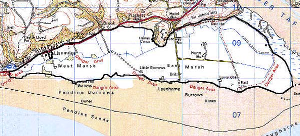
GRID REFERENCE: SN 281086
AREA IN HECTARES: 958.00
Historic Background
From the later prehistoric period until Medieval times, this area probably comprised salt marsh and patches of rough pasture on marginally higher ground, interspersed with fresh and brackish-water lagoons. In a borough charter of 1278-82 (Williams n.d.) it is stated that Sir Guy de Brian granted certain privileges and rights to the burgesses of Laugharne 'in the marsh of Talacharn called Menecors'. However, it is clear that Sir Guy kept the greater part of the marsh in his own hands as part of the demesne of the Lordship of Laugharne, as on his death in 1307, 1000 acres of pasture in 'le Marcis' were recorded in an Inquistion post Mortem (National Library of Wales 10118E Vol. 1). In 1595, the first record of habitations occurs, when the 'dairies' of Hurst House, East House and Brook House were noted in a survey (Laugharne Corporation). These three dwellings are either on the fringes of the marsh or on islands of higher ground. The term dairy indicates pasture, perhaps on a seasonal basis, as it is likely that the marsh was subjected to flooding and tidal inundation in the winter months. Prior to 1595, Sir John Perrot, Lord of Laugharne, cheated the burgesses of Laugharne out of their share of their marsh, adding it to the demesne established by Guy de Brian. Sir John used the marsh for large-scale sheep farming. However, a small part of the marsh known as 'The Lees' remained in the hands of the burgesses and was later cultivated using an open- or strip-field system (Davies, 1955). The Lees is still owned by Laugharne Corporation, though in character it is indistinguishable from the rest of the marsh. It was not until 1660 when Sir Sackville Crow came into possession of the marsh that a scheme of drainage was initiated with the construction of sea walls (Murphy, forthcoming). Drainage allowed for the establishment of new farms - a process that was complete by the tithe survey of the 1840s - and by the late 18th-century Laugharne Marsh comprised the best farmland in the county. Charles Hassall (1794, 15) described how the land could by made more productive by ridging-up the land by the use of the Dutch Plough. Drainage work continued in the 19th century. A large sea-wall armoured with stone, and a quay, were constructed at the east end of the marsh in 1800-10 by George Watkins of Broadway and connected to Coygan Quarry by a tramway (James 1991, 150), and in c. 1840 a wall across the Witchett Brook was built. Watkins's work seems to have been part of wide-ranging improvements as most of the farms (all part of Broadway estate) were rebuilt in c.1820 in a 'Georgian' style and provided with good ranges of outbuildings. A Ministry of Defence research establishment has been founded across part of the south and southeast portion of this historic landscape character area.
Base map reproduced from the OS map with the permission
of Ordnance Survey on behalf of The Controller of Her Majesty's Stationery
Office, © Crown Copyright 2001.
All rights reserved. Unauthorised reproduction infringes Crown Copyright
and may lead to prosecution or civil proceedings. Licence Number: GD272221
 Description and essential historic landscape components
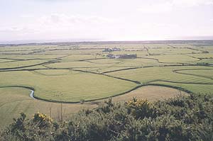
This historic landscape character area consists of flat land some 6km by 1.5km just a few metres above sea level. It is characterised by regularly-shaped fields of pasture. These fields are divided by drainage ditches which are usually accompanied by wire fences, though in the central area of the Marsh, south of Coygan Quarry, low hedges parallel some of the ditches. Towards the eastern end of the Marsh fields become less regular and tend to reflect the dendritric pattern of the pre-drainage salt marsh. Two phases of sea wall separate this area from the salt marsh to the east. Pasture is the dominant land use, mostly improved, but with pockets of unimproved ground. There is limited arable and no old woodland. Towards the western edge the land is becoming neglected and rushes are growing. Ridge and furrow, or rather in this instance ridge and drain, is everywhere apart from between the two phases of sea wall at the eastern edge. This ridge and furrow is a distinct component of the historic landscape. The settlement pattern is of dispersed farms. Farm buildings are generally two-storey and stone built. Farmhouses are in a 'Georgian' style and farms were provided with large ranges of outbuildings which were usually located formally around a yard. These early 19th-century estate farms lend a distinctive architectural signature to the area. Farms have modern agricultural buildings associated with them. The Ministry of Defence research establishment across part of the southern portion of this historic landscape character area has erased many landscape components. Many new buildings and tracks and have been constructed and the planting of shelter belts and scrubby woodland to shield the establishment from view have further altered the character of part of the area.
All recorded archaeological features relate to the reclamation and land-use described above.
There are some distinctive buildings. Date stones on several of the farms indicate a major period of rebuilding in c. 1820 by the Broadway estate. Hurst House and its farm buildings are both Grade II listed.
This is a very distinct character area with clear boundaries between it and its neighbours.