|

244 CAEO 
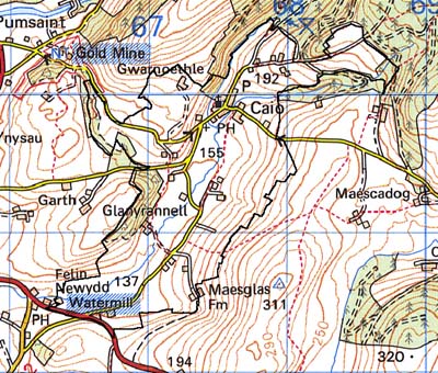
GRID REFERENCE: SN 675393
AREA IN HECTARES: 213.70
Historic Background
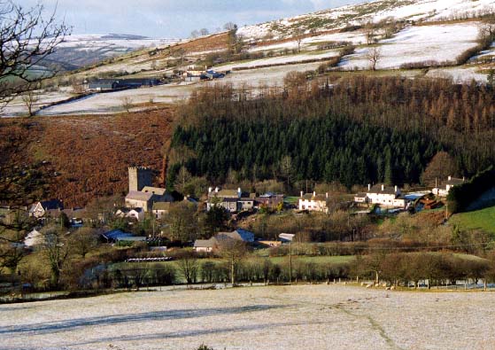
A small area surrounding the present nucleation of Caeo, at the confluence
of the Afon Annell and the Nant Frena. It once lay within Cwmwd Caeo of
Cantref Mawr which remained an independent Welsh lordship until 1284 and
largely retained native systems of tenure throughout the Medieval period.
The parish church of St Cynwyl, Cynwyl Gaeo, now at the centre of the
village, has undoubted pre-Conquest origins and lies near the Roman road
that linked the forts at Llandovery (Alabum) and Llanio (Bremia), and
the Roman gold mines of Area 243. The church may have been the most important
ecclesiastical centre in northeast Carmarthenshire before being overtaken
by Llandeilo Fawr in the 9th century (Sambrook and Page 1995, 4), and
had a number of subordinate churches during the Medieval period. St Cynwyl's
Church stands in close proximity to the Roman fort at Pumsaint (Area 241)
and the gold mines at Dolaucothi (Area 243), the notional importance of
which may have remained undiminished into Post-Roman times. A 6th century
ECM is built into the wall of the church, while two more have been found
within the parish (Area 253), one of them recording St Paulinus, the reputed
teacher of St David who founded a community which, by the 9th century,
had grown to include 'numerous buildings' (Sambrook and Page 1995, 4).
Although this community did not necessarily lie within Caeo parish, the
area may represent his 'patria'. The commote of Caeo, moreover, appears
to have formed the core of the patrimony of the Princes of Deheubarth;
Gruffydd ap Rhys, son of Rhys ap Tewdwr, the King of Deheubarth slain
by the Normans in 1093, was allowed to retain the commote by Henry I (Ab
Ithel 1860). The church, and land at the southern end of the area, were
granted to Talley Abbey c.1200 (Ludlow 1998), otherwise the Medieval Maenor
Caeo was presumably coterminous with the parish. It may have been administered
from the village site, which became the main bond settlement of the commote
(Jones 1971, 317) and which appears to be an early nucleation; indeed,
the churchyard was recorded as the site of an annual fair by George Owen
in 1601 (Sambrook and Page 1995, 22). It is possible that the radial morphology
of some field boundaries east of the village indicate the extent of former
infield lands farmed by the bond community, while the pattern of rectilinear
enclosures found elsewhere may at least in part preserve a system of strip-fields.
Enclosed strip fields are shown on hillsides to the east and southeast
of the village on the tithe map, from 1840. Gwarnoethle, a dwelling to
the northwest of the village, was recorded in a deed of 1638 as 'y gornoythe'
and became a part of the Dolaucothi estate (Jones 1987, 86). The village
developed in the 18th century when it was the centre of local droving
activity. The Roman road became an important droving road and, from the
late 18th-century until superseded by the present A482 which bypasses
the village to the south, a mail road (Sambrook and Page 1995, 23). Drovers
paddocks survive as earthworks on the south side of the village, and there
was formerly a smithy. An early chapel, originally from 1777, may have
been encouraged by droving activity. By the end of the 19th century the
village had developed into an important local centre with a post office,
school, terraced housing and two public houses. There has been some recent
development including a council estate.
Base map reproduced from the OS map with the permission
of Ordnance Survey on behalf of The Controller of Her Majesty's Stationery
Office, © Crown Copyright 2001.
All rights reserved. Unauthorised reproduction infringes Crown Copyright
and may lead to prosecution or civil proceedings. Licence Number: GD272221
Description and essential historic landscape components
This very small character area lies across hilly northwest-facing slopes
which range from 120 m to over 200 m and which are heavily wooded, including
semi-natural deciduous woods, deciduous plantations and conifer plantations.
There is a little improved pasture on the periphery. The mines are now
owned by the National Trust and run as a tourist and research centre.
The Trust has re-established a selection of mining buildings for visitor
use, re-erected head-gear over a shaft, laid out paths and walks, and
constructed car parks. However, the old mining remains are the most obvious
and massive components of the area. The most apparent mining feature is
the main Roman open-cast. In is in this deep pit with craggy, wooded slopes
that the majority of the mining buildings have been re-erected. Included
in the main-open cast are other mining features, some of Roman date such
as tanks to store water, and others of Post-Medieval date such as shafts,
adits and secondary open-casts. Mining features outside the main open-cast
litter the landscape: smaller open-cast workings (some of unknown date),
Roman tanks and leats, washing tables, spoil heaps, trial workings, inclines,
tramways, adits and shafts. There is hardly a single square metre of the
character area that has not be affected by mining.
Recorded archaeology is mainly confined to the mining features already noted, in addition to which may be mentioned the possible motte, a pounding-stone long mythologised as 'Carreg Pumsaint', and a possible holy well.
There are few buildings within the area and none are distinctive.
The mining components of this landscape provide its distinct character. Some elements such as leats and tanks run off into another character area to the northeast, but on other sides there is a sharp contrast and boundary between this area and the neighbouring areas of villages, farms and fields.