Identifying submerged landscape features - 3D All the collated 3D data was analysed by specialist software, which geo-referenced it to produce a map that located the data in relation to the coastline. This was then interpreted to select features of archaeological interest within the submerged landscape. The majority of features identified were interpreted as old river channels, usually referred to by archaeologists as palaeochannels. These are important because watercourses are often a focus for hunter-gatherer activities. Deposits within them frequently preserve organic artefacts and environmental evidence. Other mapped features include glacial lakes, valleys, low hills and areas of higher ground. Not all the features were of the same date. An analysis of their depth and stratigraphic relationship with other features allowed most to be put into one of two periods - the Palaeolithic or Mesolithic. The archaeological team was then able to recreate the landscapes as they changed over time and the land was lost to the sea. Present day water depth (bathymetry) was used to develop a model showing the relative heights of the features now buried under marine sediments to provide a general topography of the submerged landscapes, including previous shorelines and larger channel features. In addition data on known archaeological sites around the coast of Wales can also help the characterization of the likely nature and location of submerged sites. |
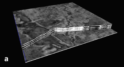
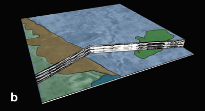
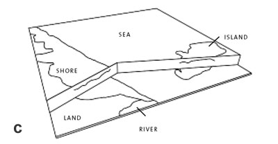
An illustration of the interpretation process for a piece of 3D seismic data from the Liverpool Bay area. The top figure (a) shows the 3D data in a 3D visualisation prior to the identification of features. Different phases of landscape features are revealed within the layers of 3D data. The middle figure (b) shows the results from the interpretation ,identifying one phase of ancient landscape features including a shoreline on the left, with the sea to the right surrounding a small island. Evidence of a river running into the sea was also identified. The final figure (c) shows a wireframe model of this interpretation that can be used to generate a map of that phase of the submerged landscape’s history.
|