
|

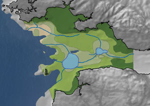
Bristol Channel during the Palaeolithic period
Bristol Channel during the Mesolithic period
BRISTOL CHANNEL - RESULTS AND SUBMERGENCE SEQUENCES Palaeolithic The Palaeolithic landscape of the Bristol Channel was that of a relatively flat valley bounded on either side by areas of higher ground that would later form Somerset, Devon and South Wales. Channels and a series of depressions within this plain suggest rivers draining the surrounding hills, flowing into lakes and then westward to the distant coastline many kilometres to the southwest of Pembroke. The lakes, rivers and tundra of the great plain would have provided Palaeolithic communities with diverse resources. The distant coast may potentially have been exploited during the winter seasons when other sources of food were less plentiful. Caves, such as Paviland on the Gower Peninsula, were used as shelter and possibly as lookout points for hunting. Mesolithic As sea levels rose the coastline retreated and Lundy Island formed a promontory sticking out into the emerging Bristol Channel. Despite inundation a considerable portion of the study area remained accessible to the communities living in the area but the changing nature of the landscape would have been obvious to Mesolithic communities. Some areas of land would have been submerged quickly but a complex mosaic of ecological niches was also created, including areas of rich wetland resources inland. Over time the land connection between England and Wales was severed, leaving only those areas interpreted as high land, such as Lundy Island, above water. The dominant position of Lundy Island would have been an ideal location to watch for game and gave access to the intertidal, saltmarsh and dry land resources that would produce gatherable food and raw materials, alongside plentiful hunting opportunities. |
The dramatic effect on the prehistoric landscape by relatively rapid inundation is most effectively shown by a series of illustrations in the above slideshow. The sequences show Bristol Channel from the end of the Palaeolithic at approximately 12,000BP until the later Mesolithic at 7,500BP. Only those areas of highland, such as Lundy Island, were left above water by the conclusion of the Mesolithic and the resulting coastlines are not dissimilar from the ones we know today. |