Home > Historic Landscape Characterisation > Upland Ceredigion > |

 Y DRUM
GRID REFERENCE: SN 720591
AREA IN HECTARES: 327.8
Historic Background
During the historic period the unenclosed nature of this area probably ensured that it was claimed by the Crown. Settlements of historic character are noted in the archaeological record, but these appear to have been abandoned by the 19th century, if not earlier. The prime use of the area in the historic period has been sheep-walk.
Description and essential historic landscape components
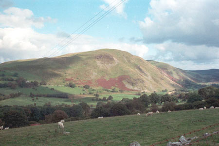
This area of unenclosed upland rises to over 500m, its lower slopes run down to below 250m. The steep slopes, particularly those on the southern flanks are craggy, while the summit areas tend to be rounded with peaty hollows. Occasional wire fences divide the area, but essentially it comprises unenclosed sheep-walk of rough grazing, with some improved pasture at lower levels. Archaeological sites provide the main historic components of the area. These comprise long huts and hut platforms of probable post-Medieval date, although they may have originated in the Medieval Period, and occasional relict boundaries of a similar date. A number of clearance cairns have been assigned to the Bronze Age, but are more likely to be associated with the post-Medieval/Medieval settlement of the area. Other sites include quarries, an area of peat cutting and a fold.
This relatively small block of upland is well defined
as it is now divorced from the major tract of mountain to the east by
a forestry plantation. To the south and northwest are enclosed and settled
valleys, and to the west the upland is less elevated and has been enclosed
and settled. Only to the northeast is there doubt as to where the boundary
between this area and its neighbour should be drawn, as their characteristics
are broadly similar.
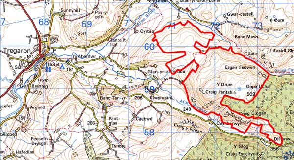
Base map reproduced from the OS map with the permission
of Ordnance Survey on behalf of The Controller of Her Majesty's Stationery
Office, © Crown Copyright 2001.
All rights reserved. Unauthorised reproduction infringes Crown Copyright
and may lead to prosecution or civil proceedings. Licence Number: GD272221