Home > Historic Landscape Characterisation > Upland Ceredigion > |

 TYN-Y-BANADL
GRID REFERENCE: SN 699669
AREA IN HECTARES: 92.9
Historic Background
In the Medieval Period this area lay within Strata Florida Abbey’s Mefenydd Grange. At the Dissolution all Strata Florida’s holdings were granted to the Earl of Essex. Soon after, the land around Swyddffynnon appears to have been purchased by the Lloyds of Ffosybleiddiaid, and later acquired by the Vaughans of Crosswood. The history of this particular area has not been researched, but it seems likely that it was unenclosed land for much of the post-Medieval Period, and perhaps enclosed in one episode. The tithe map (Lledrod Tithe Map and Apportionment, 1844) and a late 18th century estate map (NLW Crosswood Vol 1, 62) show this landscape area very much as it is today.
Description and essential historic landscape components
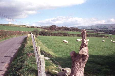
This is an area that rises from 170m at its eastern boundary with Cors Caron to 230m at its western edge. There are no buildings within this landscape area, though the farms of Tyn-y-banadl and Maesbanadlog lie close to the boundaries. A system of medium-sized regular fields predominates. This has the appearance of having been laid-out, rather than having evolved organically. Boundaries consist of earth banks topped with hedges. The hedges are in fair to good condition on the lower slopes to the east, but there is deterioration in quality with an increase in altitude, and on the highest levels hedges have all but disappeared. Here wire fences have replaced them. Improved pasture covers virtually the whole of this area.
This area is well defined to the east where it meets
Cors Caron. To the northwest is a hill - Drysgol - of unenclosed land,
and to the north and south areas comprise systems of small irregular fields.
Base map reproduced from the OS map with the permission
of Ordnance Survey on behalf of The Controller of Her Majesty's Stationery
Office, © Crown Copyright 2001.
All rights reserved. Unauthorised reproduction infringes Crown Copyright
and may lead to prosecution or civil proceedings. Licence Number: GD272221