Home > Historic Landscape Characterisation > Upland Ceredigion > |

 TANYGRAIG
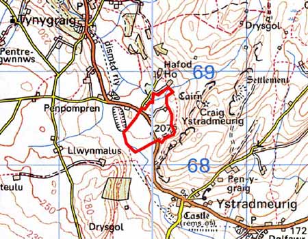
GRID REFERENCE: SN 699684
AREA IN HECTARES: 20.0
Historic Background
In the Medieval Period this area lay within Strata Florida Abbey’s Mefenydd Grange. At the Dissolution the abbey’s granges were granted to the Earl of Essex who subsequently sold them to the Crosswood estate in 1630. Most of the land in this area seems to have remained in the Crosswood estate through to the 20th century. In common with other abbey granges, it is likely that by the end of the Medieval Period, if not earlier, Mefenydd had been divided into farms which were leased out and farmed on a commercial basis. Few sources have been researched to investigate the development of this area. Cartographic sources are scarce, and the only large-scale map, the tithe map of 1843 (Spytty Ystrad Meurig Tithe Map and Apportionment, 1843) indicates that the present settlement pattern and field system had already been established.
Description and essential historic landscape components
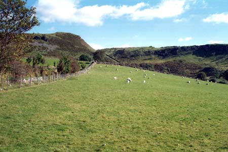
This small but characteristically distinct area lies in a saddle of land, the watershed between the south-flowing Teifi and the west-flowing Ystwyth. Its elevation is circa 220m. Dry-stone wall boundaries are an important component of this area. These walls are in fair to good condition - most are stock-proof - and parcel the land into a system of small, regular fields. Improved grazing dominates the area, with virtually no rough ground. There are few trees. This area lies within a natural route corridor, providing the easiest access from the upper Teifi valley to the northwest and the Ystwyth valley. Currently, the B4340 crosses the area, connecting Pontrhydfendigiad and Tregaron with Aberystwyth. An old railway line follows the approximate line of the B4340.
A few dispersed farms characterise the settlement pattern. These are stone built with slate roofs and date to the mid-to-late 19th century. They are relatively small, of two storeys and in the typical Georgian vernacular style, with gable end chimneys, a central front door, and two windows either side of the door and one above. A couple of late 19th century single storey worker cottages lie close to one farm. Farm outbuildings are small; older ones are stone-built and more recent ones are built of steel and concrete.
The limits of this landscape area are fairly well defined.
To the east lies the open craggy land of Craig Ystradmeurig. Lower lying
enclosed land lies to the north and south, and wetter enclosed land to
the west.
Base map reproduced from the OS map with the permission
of Ordnance Survey on behalf of The Controller of Her Majesty's Stationery
Office, © Crown Copyright 2001.
All rights reserved. Unauthorised reproduction infringes Crown Copyright
and may lead to prosecution or civil proceedings. Licence Number: GD272221