Home > Historic Landscape Characterisation > Milford Haven Area > |

SANDY HAVEN 
GRID REFERENCE: SM 861090
AREA IN HECTARES: 131
Historic Background
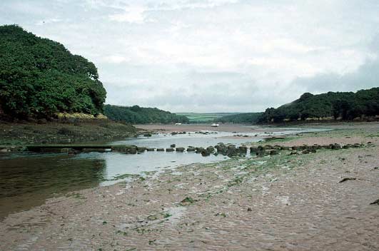
Sandy Haven is a long, branching tidal inlet on the north shore of the Milford Haven waterway, dividing the parishes of Hasguard, Herbrandston and Walwyn’s Castle (all within the medieval Barony of Walwyn’s Castle) from St Ishmael’s parish and Robeston West, which were members of the Lordship of Haverford. The character area comprises intertidal sand dunes, salt-flats and marsh, along with steep-sided, wooded valleys, which have dictated the type of land-use throughout the historic period. Prior to the construction of a road that crosses Sandy Haven at the high tide point, the main route west out of the village of Herbrandston ran across the mouth of the estuary and is still marked by stepping stones. The hamlet of Sandy Haven developed from a medieval manorial centre on the west bank at this crossing point, although it never into grew into anything other than a small settlement engaged in a variety of maritime activities. Other arms of Sandy Haven were also used as local shipping places. Late 18th century and 19th century maps show the landscape much as today with heavily wooded valley sides and a tidal and marshy valley floor.
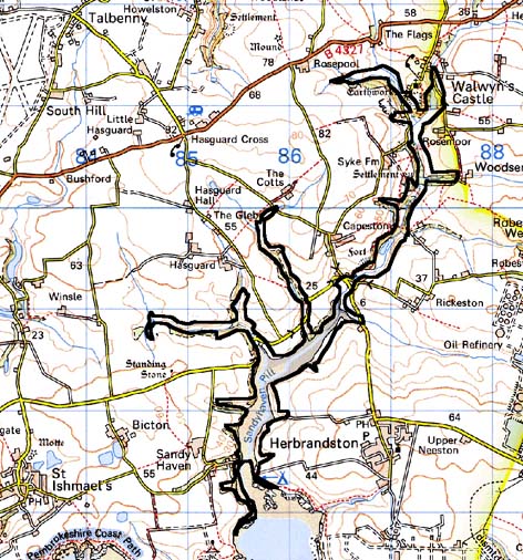
Base map reproduced from the OS map with the permission
of Ordnance Survey on behalf of The Controller of Her Majesty's Stationery
Office, © Crown Copyright 2001.
All rights reserved. Unauthorised reproduction infringes Crown Copyright
and may lead to prosecution or civil proceedings. Licence Number: GD272221
Description and essential historic landscape components
Sandy Haven historic landscape character area comprises the tidal inlet
and upper reaches and branches of a narrow, steep-side valley as far upstream
as Walwyn’s Castle, a distance of about 5 km. There are no inhabited
buildings in this area. The valley sides and in the higher reaches the
valley floors are heavily cloaked with deciduous woodland. The lower valley
is tidal. Here there are extensive areas of salt marsh, mud flats and
sand. There are numerous easy access points down to the haven from neighbouring
farmland. Old limekilns and occasional quays and jetties at some of these
points testify to the former importance of coastal trade and shipping
in this area. Pleasure craft now make use of the sheltered haven as a
safe mooring. Sandy Haven hamlet, the main settlement along the shore,
has been assigned to a different historic landscape character area. A
large, modern, but no longer active quarry lies to the upper end of this
area. Other archaeological sites in addition to limekilns and quays include
mill sites, a fish trap and several 20th century shipwrecks.
Although there are many connections between this area and its neighbours, its essential historic landscape components are completely different. Neighbouring areas comprise farms, villages and fields. Sandy Haven consists of woodland and a tidal estuary.
Sources: St Ishmael’s Parish tithe map 1839; Robeston West Parish tithe map 1843; Stainton Parish tithe map 1843; Walwyns Castle Parish tithe map 1842; PRO D/RKL/1194/11 & 20