Home > Historic Landscapes > Black Mountain and Mynydd Myddfai > |

228 CILGWYN - LLWYNWORMWOOD 
GRID REFERENCE: SN 754308
AREA IN HECTARES: 1288.00
Historic Background
An area southeast of the River Tywi lying in the former Cantref Bychan
which was invaded by the Anglo-Normans under Richard Fitz Pons who established
a caput at Llandovery in 1110-16 (Rees n.d.). It was acquired soon after
by the Clifford lords of Brecon as the Lordship of Llandovery but retained
native tenurial customs until the end of the Medieval period when it was
incorporated within modern Carmarthenshire. The area was divided between
two commotes, Hirfryn to the north and Perfedd, specifically Maenor Myddfai
(and Myddfai parish), to the south. The latter may have been administered
from Myddfai itself but Cilgwyn Mansion had been established by the 16th
century (Jones 1987, 30), and the nearby mill is marked by Rees on his
map of 14th century south Wales (Rees 1932). With 3820 acres in Myddfai
parish in 1873, the occupants of Cilgwyn Mansion, the Gwynne-Holfords,
were the chief family of the parish. A second gentry house nearby, Glasallt,
is said to have been the home of the Owen family since 1508 (Jones 1987,
80). Llwynwormwood in the northern part of the area, now gone, was a later
18th century gentry house and home of the Williams family, also of Dolgarreg
and the second family of Myddfai parish (Jones 1987, 122). A small emparked
area also lies around Glansevin, at the southern end of the area, which
had been the home of the Lloyd family since the 16th century and was assessed
at 8 hearths in 1670 (Jones 1987, 78); it is now a hotel. The landscape
within the area exhibits a varied pattern of enclosures; those to the
south are irregular and may have been established by the early Post-Medieval
period, while those to the north are more regular and probably later in
date. The landscape around Cilgwyn and Llwywormwood was extensively emparked
in the 18th- and 19th-century with much tree-planting. Small-scale mining
activity is represented by Allt Rhydings and Paradise Lode, small copper/lead
shafts in the north of the area, and a lead/zinc shaft in the south of
the area. There has been little recent development.
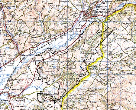
Base map reproduced from the OS map
with the permission of Ordnance Survey on behalf of The Controller of
Her Majesty's Stationery Office, © Crown Copyright 2001.
All rights reserved. Unauthorised reproduction infringes Crown Copyright
and may lead to prosecution or civil proceedings. Licence Number: GD272221
Description and essential historic landscape components
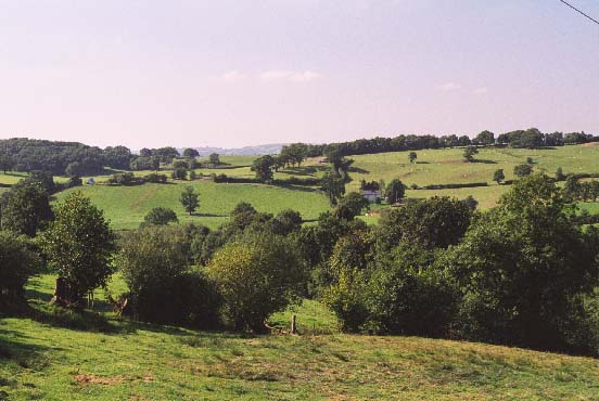
Cilgwyn-Llwynwormwood character area lies across a wide hilly ridge which
trends southwest-northeast on the south side of the Tywi valley between
Llandovery and Llangadog. The ridge rises from approximately 60 m on the
valley floor to achieve heights of over 180 m. The area is heavily wooded.
This consists of deciduous woodland on steep valley sides interspersed
with and under-planted by 20th century conifer plantations. There are
also substantial conifer plantations on the ridge crests. Although some
of the deciduous woodland is probably ancient, especially that on the
steeper slopes, much has the appearance of 18th- or 19th-century plantations,
part of the estate landscape. There are several large estates or former
estates in the area. The mansion of one of the largest, Cilgwyn, still
exists, along with various associated relict garden features, but the
other main house of the area, Llwynwormwood is now a ruin. Dolgarreg and
Cwm-Rhuddan, two lessor major houses still stand. Outside the wooded areas,
the main land-use is pasture. This has been divided into fields which
are large and fairly regular on higher levels, smaller and more irregular
at lower levels. Earth banks with hedges form the boundaries to the fields,
but apart from alongside roads and tracks hedges are in very poor condition,
especially so at higher elevation, and are either overgrown or derelict.
Wire fences provide most of the stock-proof boundaries. Many hedges have
distinctive trees, and there are individual trees and small clumps present
across much of the area. Parkland is still present as at Cwm-Rhuddan,
but virtually the whole area seems to have been subjected to landscaping
by the estates in the 18th- and 19th-century. Outside the major houses,
the settlement pattern is of dispersed farms and other dwellings. Farmhouses
are substantial, stone-built, generally 19th century in date and have
a wide range of stone outbuildings reflecting estate management. Most
farms have modern agricultural buildings. Other dwellings are mostly 19th
century cottages or houses, usually in the vernacular style, with a few
20th century buildings.
Recorded archaeology comprises a possible hillfort, three metal mines, estate and parkland features, and several unknown cropmark/earthwork/landform features.
There are many distinctive buildings of which the 18th century Cilgwyn house and one of the Llwynwormwood park lodges, from the 18th- or early 19th-century in picturesque 'estate' Gothic style, are Grade II listed. Glansevin, from the 18th- and 19th-century with Classical features, is Grade II listed. Mansions, parkland and woodland distinguish this area and mark it out from the neighbouring areas of farms and small fields.