|

243 DOLAUCOTHI GOLD MINES 
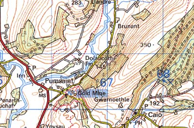
GRID REFERENCE: SN 664402
AREA IN HECTARES: 44.84
Historic Background
A very small character area encompassing the gold mines at Dolaucothi.
Although there is evidence for earlier exploitation, the present mining
complex was initiated under the Romans, and represents the most advanced
mine-working yet discovered in Britain; their end product was bullion
for the imperial mints and may have been one of the motives for the conquest
of Britain. Most of this section is taken from Jones and Lewis, 1971,
augmented with Burnham passim. The mines were established during the initial
wave of subjugation of southwest Wales, in 75-80 AD, and continued production
until the end of the 4th century. A timber drainage wheel from one of
the deep stopes has been C14 dated to c.50 BC, while coins found in the
vicinity run from the 1st century down to the reigns of Valentinian and
Valens, 364-375 AD (James 182, 33). Mines such as these remained under
military control and to this end a fort was established on level ground
at Pumsaint immediately to the west (Area 241). The area exhibits a complex
of adits, hushes, stopes and areas of fire-setting characteristic of early
mining techniques, but not necessarily all are Roman. It has been claimed
(Jones 1994, 88) that some gold extraction persisted into the post-Roman
period, but that it may have exploited alluvial deposits. It was certainly
being undertaken during the later Medieval period, possibly under the
Premonstratensians of Talley Abbey (a possible spoil tip has long been
interpreted as a motte). It continued into the Post-Medieval period, and
fairly large quantities of 17th century pottery have been found low down
in one of the main leats and dams (James 1982, 33). After a hiatus, mining
resumed in c.1870 and lasted until 1910, under the direction of an Australian,
a Mr Mitchell, who reopened many of the earlier workings. A second modern
operation began in 1934 under 'Roman Deep Holdings Ltd' and continued
until the outbreak of the Second World War, during which the drainage
wheel was recovered. The site was acquired by the National Trust after
the war.
Base map reproduced from the OS map with the permission
of Ordnance Survey on behalf of The Controller of Her Majesty's Stationery
Office, © Crown Copyright 2001.
All rights reserved. Unauthorised reproduction infringes Crown Copyright
and may lead to prosecution or civil proceedings. Licence Number: GD272221
Description and essential historic landscape components
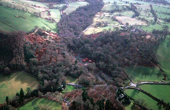
This very small character area lies across hilly northwest-facing slopes
which range from 120 m to over 200 m and which are heavily wooded, including
semi-natural deciduous woods, deciduous plantations and conifer plantations.
There is a little improved pasture on the periphery. The mines are now
owned by the National Trust and run as a tourist and research centre.
The Trust has re-established a selection of mining buildings for visitor
use, re-erected head-gear over a shaft, laid out paths and walks, and
constructed car parks. However, the old mining remains are the most obvious
and massive components of the area. The most apparent mining feature is
the main Roman open-cast. In is in this deep pit with craggy, wooded slopes
that the majority of the mining buildings have been re-erected. Included
in the main-open cast are other mining features, some of Roman date such
as tanks to store water, and others of Post-Medieval date such as shafts,
adits and secondary open-casts. Mining features outside the main open-cast
litter the landscape: smaller open-cast workings (some of unknown date),
Roman tanks and leats, washing tables, spoil heaps, trial workings, inclines,
tramways, adits and shafts. There is hardly a single square metre of the
character area that has not be affected by mining.
Recorded archaeology is mainly confined to the mining features already noted, in addition to which may be mentioned the possible motte, a pounding-stone long mythologised as 'Carreg Pumsaint', and a possible holy well.
There are few buildings within the area and none are distinctive.
The mining components of this landscape provide its distinct character. Some elements such as leats and tanks run off into another character area to the northeast, but on other sides there is a sharp contrast and boundary between this area and the neighbouring areas of villages, farms and fields.